


SEJournal Online is the digital news magazine of the Society of Environmental Journalists. Learn more about SEJournal Online, including submission, subscription and advertising information.
April 25, 2018
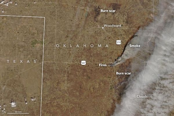 |
| Satellite image of the Rhea fire burning in Western Oklahoma, Dewey County, on April 13, 2018, one of a series of fires prompted by persistent drought, high temperatures and strong winds in the area. The National Weather Service reported that one of the fires was burning hot enough to produce a pyrocumulus cloud that could loft smoke plumes several kilometers into the air, where they can encounter winds capable of transporting the smoke over long distances. Photo: NASA Earth Observatory |
TipSheet: Where There’s Smoke, There's ... a Health Threat
Stinging and burning eyes. Gasping for breath. At the height of a bad wildfire, the problems are immediate to those nearby.

But nowadays, wildfire “season” is pretty much a year-round phenomenon, with big regional fire clusters going on for months. From satellites, you can see how the smoke drifts across continents, with exposures to lighter smoke a significant health threat to people far away as well.
Which is why the health effects of wildfire smoke need reporting — the human damage reaches way beyond the flames.
That hazard was reemphasized when a recent study, published in the Journal of the American Heart Association, warned that wildfire smoke damages not just the lungs but also heart health. The study correlated emergency room visits with smoke conditions and found not only increases in heart attacks, but also increases in strokes.
The problem is worse for those whose health is already vulnerable: people over 65, infants, those with asthma or other lung conditions. The denser the smoke, the worse the health effects.
You can do your audience a service by reporting on daily wildfire smoke conditions, by reporting on the health threats they present and by informing your audience about how to minimize them.
Start by monitoring smoke
When it comes to smoke, your eyes and nose tell you a lot. But satellites, maps and instruments can tell you even more.
One of the handiest tools for tracking wildfire smoke is the U.S. Environmental Protection Agency’s AirNow app, which shows you current wildfire pollution levels on a searchable, scalable map.
AirNow is actually the work of a network that includes the National Aeronautic and Space Administration, the National Park Service, state and local agencies, Mexico and Canada. It shows you where the fires are, as well as the air quality at associated monitoring stations. Its website includes links to a large array of information about wildfire and health.
EPA also tracks visibility and regional haze — a phenomenon largely caused by particulate matter (sometimes from smoke).
NASA satellites routinely capture quite spectacular images of wildfire smoke plumes (klaxon alert for online and video publishers). A lot of them are on NASA’s own wildfire and smoke page. Such images help people see the transcontinental reach of smoke. NOAA satellites also produce fire and smoke maps.
Also handy are forecasts of wildfire smoke. The National Oceanic and Atmospheric Administration offers air quality forecast maps that include smoke, and NOAA’s National Weather Service offers fire weather forecasts in map form.
Health info on hazards of smoke is plentiful
The health problems caused by wildfire smoke are well-documented and not controversial.
Don’t take our word for it — take it from the Centers for Disease Control. “Wildfire smoke can harm you in multiple ways,” a CDC publication warns. “Smoke can hurt your eyes, irritate your respiratory system, and worsen chronic heart and lung diseases.”
Even more important is the advice about how people can protect their health during smoke events. That may include staying indoors with windows closed, using an air purifying machine, avoiding other combustion indoors and talking to your doctor. Paper air masks do little good; the one that may help some is a “N95” mask, if worn properly.
You can get other information on wildfire smoke and health from EPA’s AirNow site, EPA’s guidance for health officials, state health departments (like Washington’s) or even regional air pollution agencies.
There is even an interagency program — the Wildland Fire Air Quality Response Program — led by the U.S. Forest Service. It assesses smoke threats and communicates them, as well as doing monitoring and smoke dispersion modeling. And it serves as a reminder that the people most at risk from the health effects of wildfire smoke are often the firefighters themselves.
If you are covering wildfire issues, you may also find lots of additional leads and tips in SEJournal Online’s last backgrounder on wildfire.
* From the weekly news magazine SEJournal Online, Vol. 3, No. 17. Content from each new issue of SEJournal Online is available to the public via the SEJournal Online main page. Subscribe to the e-newsletter here. And see past issues of the SEJournal archived here.
SEJ Publication Types:
Topics on the Beat:
Region:
Visibility: